|
|
|||||||||||||||||||||||||||||||||||||||||||||||||||||||||

|
|
|
|
|
General |
|
|
|
|
|
Links |
![]()
[Other villages]
Valtesiniko
Kleitoros' Municipality

|
Information |
|
| How to get there | |
| Population (census 2001) |
Valtesiniko 675 persons
Kourouveli 15 persons Olomades 51 persons |
| Distance from Tripoli | 63 Km |
| Postal Code | 22014 |
| Central Church | Agioi Theodoroi |
| Festivals |
June 8th August 15th Saint George's Commemoration Day |
| Altitude | 1160 |
| Community Clinic | |
| Drug Store | NO |
| Nursery School | |
| Elementary School | |
| Junior High Shool-High School | NO |
| Tourist resorts | |
| Restaurant-Tavern | |
| Cafeteria | |
| Market | |
| Gas Station | NO |
| Banks-ATMs | NO |
| Offices - Foundations | Police Station - Citizen Service Center |
| Museums |
|
|
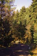
Main road, 63 km away from Tripoli |
|
From Tripoli, take the road for Pyrgos. After passing Vytina and Kampeas, turn right at the 53th km (there is a relevant sign reading: TO VALTESINIKO). You will arrive at your destination after a 10km drive through beautiful firs (Road D10). The road is entirely asphalt paved.
|
![]()


Last update 2008, 23-8